Water level monitoring scheme is an early warning system for monitoring river water level, which includes sensors, acquisition equipment, communication equipment, management equipment, etc., with user management, hydrological information management, forecast and early warning modules. It can collect the database and analyze the front-end perception data, and issue the forecast and early warning in time. Users can grasp the hydrological status of the river in real time and make management decisions through the system.
Main techniques of traditional water level monitoring
1, Ultrasonic water level meter: ultrasonic measurement technology, non-contact measurement, external output analog signal or digital signal. The technology is non-contact measurement, easy to install, almost free from external temperature, humidity and other environmental conditions. However, the measurement accuracy is low, and it is more restricted by external environmental conditions such as temperature and humidity, and there can be no foreign body barrier between it and the object to be measured.
2, Pressure type water level meter: input type pressure level meter, the core is mostly silicon piezoresistive, external output analog signal or digital signal. The technology was developed early, the technology is mature, and the measurement accuracy is high, but the water level meter needs to be fixed underwater, and the installation and later maintenance are troublesome.
3, Bubble type water level meter: through the pressure balance to achieve the purpose of measurement, external output analog signal or digital signal. This technology is almost not limited by the distance between the water level station to be measured and the host of the bubble water level meter, with high measurement accuracy and easy maintenance, but it also needs to fix the gas volume underwater, which is troublesome for installation and later maintenance. On the whole, the traditional water level monitoring technology will encounter some problems in practical work, such as low precision, difficult integration, complex installation and easy to be affected by the external environment.
Leading the new trend of water level monitoring: WTR10 high precision water level radar
Working principle of water level radar: the transmitter built in the radar emits high-frequency electromagnetic pulses with a frequency in the millimeter band. When the electromagnetic pulse encounters the surface of the water body, some of the signals will be reflected back to the millimeter wave radar, and the receiver built in the radar will receive these reflected millimeter wave signals. By analyzing the frequency change of the reflected signal, the distance between the water surface and the radar can be accurately judged, that is, the height of the water level. At the same time, the fluctuation state of the water surface can also be analyzed to obtain the dynamic parameter information of the water flow and liquid level, and provide accurate water level data support for water conservancy dispatching. Through the statistical analysis of the historical and real-time water level data, the trend of water level change can be judged and the early warning can be issued to improve the early warning and response ability of the waterlogging control system.
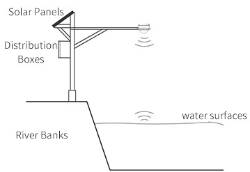
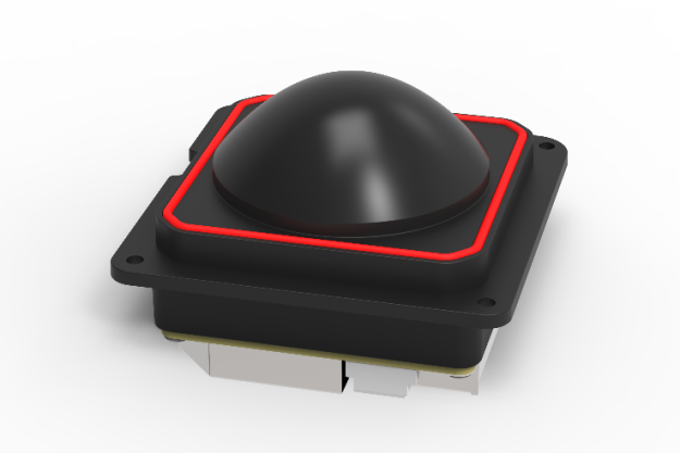
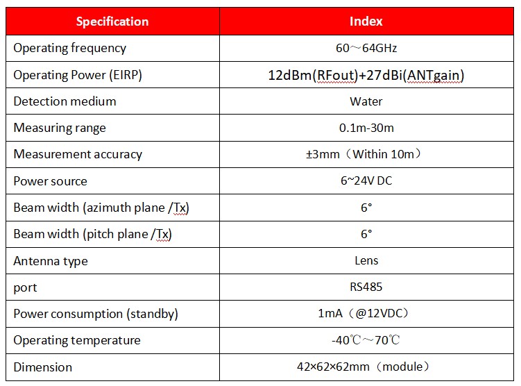
WTR10 water level measuring radar is a 60GHz radar sensor module independently developed by Nanoradar. It adopts FMCW technology and lens antenna design. The measuring distance is 0.1~30m, the measuring accuracy is 3mm within 10m, and the beam Angle is 6°*6°, which can effectively filter the clutter interference in the application environment. The product has low power consumption (low power mode 0.15W), accurate and stable measurement results, can be powered by solar energy, lightweight design (module size 42×62×62mm), and is not affected by environmental factors such as temperature, pressure, sediment, dust, river pollutants, floating objects on the water surface, and air, with good reliability and ease of use. It can meet the application needs of rivers, lakes, tides, reservoirs and other fields.

Product parameter

Product highlights
◆ Low power consumption, more energy saving: The use of low power chip, sleep mode current is only 1mA, can significantly reduce the equipment's own energy consumption, so as to bring power savings to customers, reduce customers' operating costs.
◆ High precision, strong performance: high measurement accuracy, has been the Ministry of Water Resources hydrology instruments and geotechnical instruments quality supervision and testing center test report.
◆ Easy integration: industrial application standard Modbus protocol, support multiple devices to quickly access the Internet of Things platform, and transfer to the remote network, to achieve data acquisition, all-weather detection.
◆ Rich product form: the user can customize the shell design under the module product form, the user can directly use the whole product form, and the different product forms can meet the diversified needs of users.
Application scenario
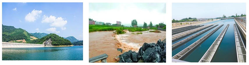
Natural water level monitoring
Urban flood monitoring during flood
Assist water treatment operations